|
This is a print of an engraving of a map of Albany probably made by a British army engineer showing the settlement/city following the end of the French and Indian Wars. It is dated "1765" - the year it was published in London as part of a collection of military maps of places in New York and beyond. This image presents an intriguing yet puzzling perspective on the Albany landscape. It is dominated by a proposed (and never built) stockade that would box in the community on three sides. It shows terrain and landmarks of strategic value. Within a year or so, the stockade and most other military features were being dismantled as they no longer were in use. This was the last of a number of maps made by agents of the British army. 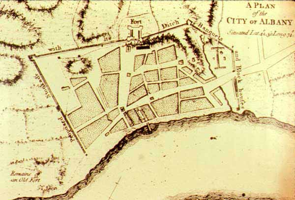 The map also shows the "Remains of an Old Fort" (Fort Orange) in the lower left hand corner; a knoll within the stockade above today's South Pearl Street we believe is the legendary "Gallows Hill"; the first visualization of a dock extending out from today's Exchange Street (Mark Lane); a number of unidentified military structures; and a greatly expanded (yet labeled as "proposed") stockade. This piece of cartography presents an interesting comparative to the city of just five years later as shown in a Albany map drawn by Albany resident Robert Yates. Oversize, reproduction print of unknown origins in the Graphics Archive of the Colonial Albany Social History Project. It most likely was made from A Set of Plans and Forts in America - reduced from Actual Survey by Mary Ann Roque, "Topographer to the Duke of Gloucester," and first published in London in 1765. That work can be found in a number of prominent repositories. A beautifully digitized version of that work appears online. I first saw and read about it in Munsell's Annals of Albany. First posted 2003; revised 2/10/11 |