|
The Public Square
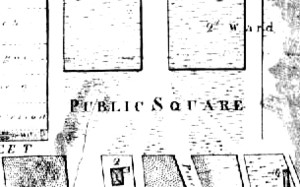
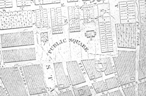
This open space was located above the settled part of the colonial city and appeared on the community landscape during the 1780s or 90s as settlement spread west from the State Street/Market Street core. Previously, it had appeared on colonial cartography as a vacant area below and east of the fort. With the removal of the stockade and the dismantling of the fort following the Seven Years War, the area above the colonial city began to be developed. The Square was first named on the development version of the De Witt map dated 1794. The Square's hillside location and fact that the King's Highway (also called Lion Street and later Washington Avenue) ran through it probably precluded its long term development. However, for some of the time between the 1780s and the 1820s, it was bounded on the south by Deer Street and the municipal cemetery, on the north by Elk Street, by Eagle Street on the east, and by the hill on the west. The "first" new jail sat on the hillside and was bounded by Eagle and State Streets, and by upper Maiden Lane.
Sources: The basic resources for comprehending this landmark are cartographic. Detail from a large city map made by Evert Van Allen and dated 1818. Copy in the Graphics Archive of the CAP. Original may be in the map collection of the New York State Office of General Services. Home | Site Index | Navigation | Email | New York State Museum posted: 7/20/03 |