View of Albany in 1686

(Click on any feature)


road or trail to Schenectady Schuyler house Dutch Reformed Church Albert Ryckman's brewery city hall - also referred to as the Stadt Huys Rensselaerswyck River road leading to the Patroon's house the English fort the Hill - trading area Roseboom's Gate Market Street Market Street Market Street The Ruttenkill flowed into the Hudson River The Ruttenkill meandered across South Pearl The upper Ruttenkill Court Street Cow path later Pearl Street Lutheran church Dutch church burial plot Second Ward The Indian Houses as shown by Roemer Maiden Lane ferry vicinity of Fort Orange

Roemer Map

Census of Households

Timeline


notes

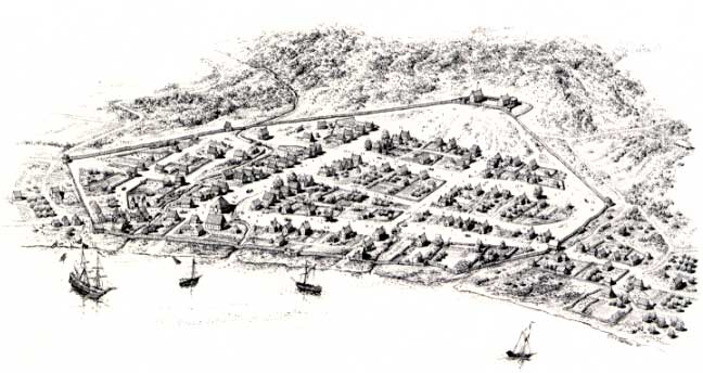
Overview diagram entitled "Albany, N. Y., 1686," ink on mylar by L. F. Tantillo (1985). This image informed by the first census of householders taken in 1697. It is based on the Roemer Map of 1698 and on property information derived by the Colonial Albany Social History Project. It represents our ambition to develop materials to help visualize this early American city in one of its earliest incarnations. The diagram was created for the programs supporting the Albany Tricentennial of 1986. Collection of Stefan Bielinski.


Home | Site Index | Navigation | Email | New York State Museum


first posted: 01/25/02